Exceptional Heatwaves in Other Parts of the World Contrast with Britain’s Cool Start to June

- by Admin
- June 15, 2024

Britain has had a notably cool first half of June, thanks to frequent northerly and north-westerly winds, with temperatures widely running about 2C below what we saw during May. Cooler-than-average temperatures are forecast to persist in most parts of Scotland this weekend. Still, elsewhere, temperatures will recover close to the long-term normal for this time of the year. Near-average temperatures look probable during the coming week, but nothing particularly hot.
North American heat dome
However, some other parts of the world have been seeing exceptional heat, which is set to continue. Much of North America is expected to see substantial heatwaves during the coming week, with persistently high temperatures in the west and a “heat dome” developing over the northeast between Monday and Wednesday, which has the potential to persist into Thursday and Friday.
A ‘heat dome’ is a high-pressure system that traps hot air and can cause prolonged periods of excessively hot weather.
This heat dome will be associated with a ridge of high pressure, which will pull hot air in from southwestern North America. There are warnings that some major cities, including New York, could breach 100F (38C), a rare event in this region of North America.
Heatwaves in south-eastern Europe, especially Greece
In Europe, north-west Europe will stay relatively cool during the coming week, though, with temperatures recovering close to the long-term normal generally across the region, not just in Britain. However, it has recently been sweltering at times in south-eastern Europe, and this situation is forecast to continue. Many schools have closed in Greece due to heat waves, defined as events where temperatures exceed 38C for at least three days in that part of the world.
The ongoing heatwave can partly be explained by the synoptic weather pattern, for while north-western Europe has been under low pressure and/or northerly winds, south-eastern Europe has been affected by frequent southerly winds pulling hot air in from North Africa. However, this is likely to be Greece’s earliest heatwave on record (by the 38C over three days definition) – usually, they only happen in July or August, or occasionally late June. One key culprit is the exceptional heat that has persisted over much of North Africa since the start of June, meaning there are hotter air masses to tap into. North Africa has warmed somewhat faster than the global average in summer during the past few decades.
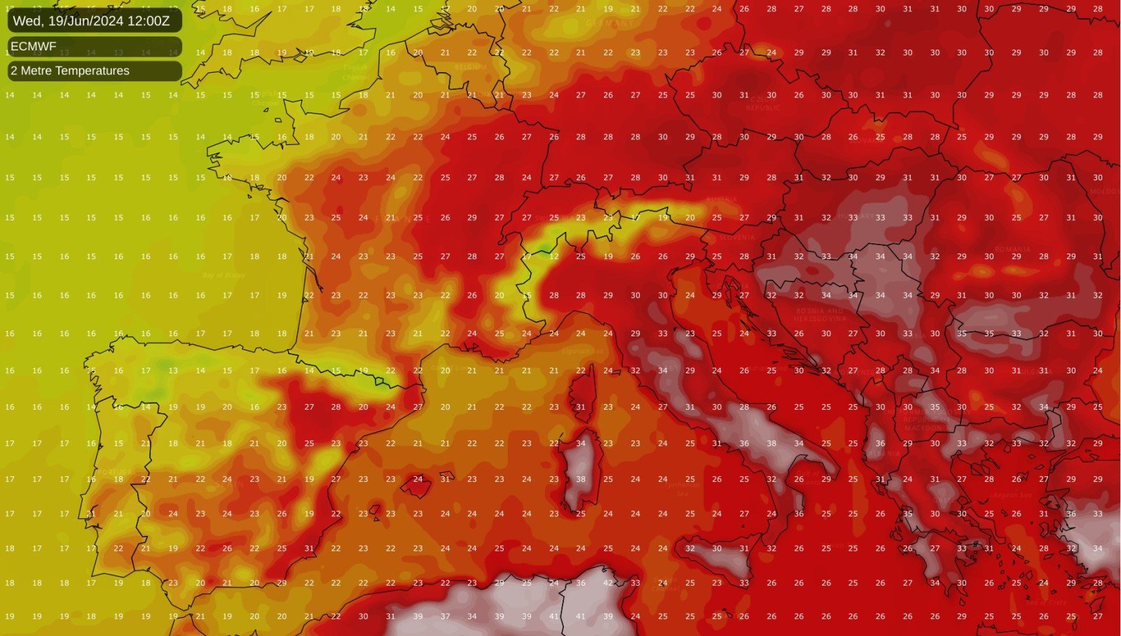
The heat will subside in south-eastern Europe during the next few days, with daytime temperatures mostly in the mid-30s Celsius. However, it will return late this week and into next weekend, with a high likelihood of temperatures getting into the low 40s Celsius in parts of Italy as well as Greece.
For Britain
Sunshine and showers will dominate the weather for most of us during the weekend and on Monday. Slow-moving low pressure will be nearby, but not much frontal activity, helping to keep the weather bright and showery rather than dull and wet. Some thunder is possible, especially today and especially in eastern England. However, parts of Scotland will see some more persistent rain during the weekend, so daytime temperatures will remain relatively cool.
A ridge of high pressure is forecast to cross the country between Tuesday and Thursday, bringing most places a fair amount of dry, sunny weather and temperatures creeping a little above average, generally in the low 20s Celsius. Although it will often be cloudier in northern Scotland and in the far south of England, some rain may move into southern England into Thursday.
For the longer term, it looks likely that we will see a pattern shift which will promote warmer than average temperatures, with predominantly west to south-westerly winds and ridges of high pressure moving in from the Azores at times, interspersed with periods of more unsettled weather with low-pressure systems coming in off the North Atlantic. It is common for the weather patterns to shift in this way in late June, with a strengthening of the Azores High and stronger westerlies on its northern flank, though with the jet stream pushing northwards, for Britain, the westerlies will probably only be intermittent.
Heat building later in June?
There is some chance of some of that North African and southern European heat making its way to the British Isles towards the end of June, depending on whether the ridges of high pressure from the Azores align in such a way that we pull in hot air masses from the south and south-east, but this is not a certainty. Regardless, it is highly unlikely that Britain will end up approaching the warmest June on record this year because of the cool first half, with temperatures running 1 to 2C below the 1991-2020 long-term average. To get a record-warm June, we would need temperatures to be some 6 to 8C above average in the second half, which looks extremely unlikely. The most likely outcome is that the second half of June may come out 1 to 2C warmer than average, resulting in June as a whole being very average. Because of the warm May that we’ve just had, June may not be substantially warmer than May this year.
The Latest News
-
December 23, 2024Sharp fall in UK business activity forecast as economic gloom deepens
-
December 22, 2024Elon Musk’s British cousin reveals how brutally world’s richest man snubbed him: ‘I’m shocked that…’
-
December 22, 2024‘Labour will torpedo my firm’: One of Britain’s OLDEST family businesses says inheritance tax plans could destroy his finances in ‘blink of an eye’ after 250 years of trading
-
December 22, 2024UK Weather: Wind messes up UK travel plans
-
December 22, 2024Life in one of Britain’s most miserable towns: Locals in Barking blast council ‘shambles’ and say shopping centre is so empty it is like living in a ‘ghost town’


