UK weather live: Commuters suffer delays due to heavy rain and flooding as new Met Office warning issued

- by Admin
- September 26, 2024

Rail passengers face delays to their journeys due to flooding this evening as the Met Office issues a fresh weather warning for wind over the weekend.
The railway line between Swindon and Bristol Parkway is blocked, which has resulted in services between London and Bristol and Wales having to be diverted, where possible, said National Rail.
It means passengers are facing delays of up to 30 minutes.
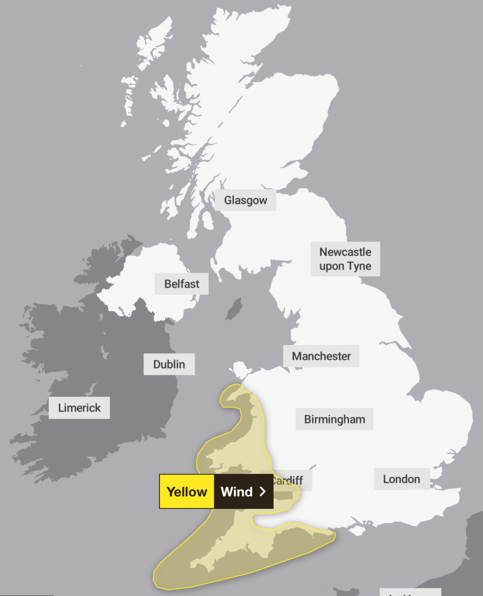
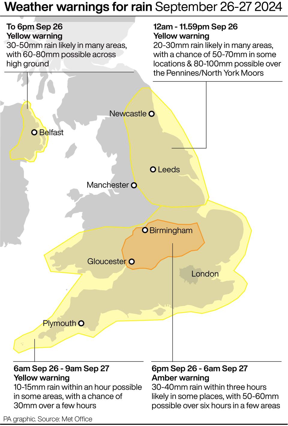
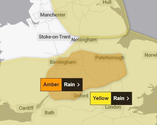
The disruption follows heavy rainfall this week, and comes ahead of a new weather warning from the Met Office with areas of south west England and Wales to be blasted by winds of up to 60mph on Sunday.
The forecaster has issued the yellow weather warning for the region on Sunday from 9am until 11:59pm,
“A yellow warning for wind has been issued for much of Sunday across portions of southwest England and south and west Wales, where gusts could reach or even exceed 60 mph on exposed coasts, and 50-55 mph more widely,” Met Office Deputy Chief Meteorologist Dan Holley said.
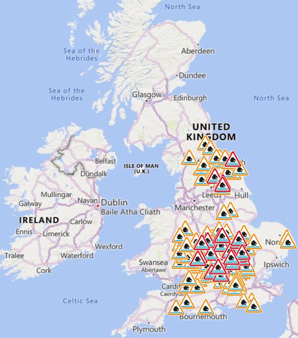
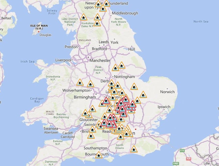
The Environment Agency also has 59 flood warnings in place across England, meaning flooding is expected, and 115 flood alerts, meaning flooding is possible.
Key Points
-
117 flood alerts and 62 flood warnings in place
-
Met Office issue new weather warning for weekend
-
Motorists rescued from M5 amid flooding
-
Tornado alert issued
-
Amber alert issued for heavy rain
Met Office issue new weather warning for weekend
17:00 , Joe Middleton
The Met Office has issued a fresh weather warning for wind over the weekend as many continue to struggle with flooding.
Areas of south west England and Wales will be blasted by winds of up to 60mph on Sunday as a yellow weather warning is set to come into place at 9am and remain until 11:59pm.
The forecasters warned that coastal routes will likely be affected by large waves while power cuts and delays to transportation will be seen.
“Winds will strengthen from west to east during Sunday, with gusts of 50-55 mph likely in places, especially near coasts and over/to the west of high ground, perhaps exceeding 60 mph in the most exposed areas,” the Met Office said.
“This will be accompanied by outbreaks of rain, heavy at times, which could lead to some surface water and spray. Winds will gradually ease across Wales and inland parts of southwest England through Sunday evening and night, but it may remain fairly windy along some coasts of southern and southwestern England during Sunday night.”
Flood warnings still in place
16:00 , Alex Ross
Despite a brief respite in the tottential downpours on Friday and Saturday, there are still 59 flood warnings in place across England, as of 3.30pm on Friday.
Many appear in the east Midlands where there was an amber warning for flooding last night.

Eel washed up
15:27 , Alex Ross
Not what you expect on a round of golf – but at Brent Valley Golf Course, players spotted this eel in lying water off the fairway.
Where is Sunday’s weather warning for?
14:33 , Athena Stavrou
The Met Office has issued a further yellow weather warning of strong winds which may cause disruption across the south west of England and Wales on Sunday.
Winds will strengthen from west to east during Sunday, with gusts of 50-55 mph likely in places, exceeding 60mph in the most exposed areas.
Winds will gradually ease across Wales and inland parts of south west England through Sunday evening and night, but it may remain fairly windy along some coasts of southern and south-western England during Sunday night.

Will it stop raining next week?
14:10 , Athena Stavrou
The UK has seen a huge amount of rainfall in the past week, marking a sharp end to summer.
But will it dry up next week at all? The Met Office says potentially.
The forecaster said that while Monday will remain wet, it should become somewhat drier and brighter more widely around midweek. However, there are signals for the potential of further wet and windy weather towards the end of next week.
Five day forecast
13:48 , Athena Stavrou
Today:
Morning heavy rain clearing central and southern parts of the UK. Then a bright day for many, with sunny spells and scattered showers. A colder feeling day than of late, especially in the south with a brisk northerly wind.
Tonight:
Showers tending to become confined to the northwest through the evening and overnight. Many areas dry, with prolonged clear spells. A chilly night to come, with a patchy frost possible.
Saturday:
Most places dry with sunny spells. A scattering of showers across northwestern parts, most frequent across Scotland. A rather cold feeling day for many with winds easing.
Outlook for Sunday to Tuesday:
Wet and windy weather slowly moving northeastwards across the UK through Sunday and into Monday, mainly affecting England and Wales. Gradually turning drier and brighter on Tuesday from the west.
More from the Met Office on new weather warning
13:19 , Athena Stavrou
Speaking about the warnings of strong winds to hit the UK over the weekend, Met Office Deputy Chief Meteorologist Dan Holley said: “After a drier interlude for many on Friday, Saturday and early Sunday, attention shifts to a deep area of low pressure to the southwest which will bring rain and strong winds to parts of the UK, potentially impactful for some.
“A Yellow warning for wind has been issued for much of Sunday across portions of southwest England and south and west Wales, where gusts could reach or even exceed 60 mph on exposed coasts, and 50-55 mph more widely. This system will gradually track eastwards through Sunday and into Monday and will bring another spell of wet weather fairly widely across the UK.
“We’re continuing to monitor the rainfall with this system, as rain falling on saturated ground in flood-hit areas has the potential to cause further impacts. Stay up to date with the latest forecast as further warnings could be issued in the coming days.”

Met Office issue new weather warning for weekend
12:56 , Athena Stavrou
The Met Office has issued a fresh weather warning for wind over the weekend as many continue to struggle with flooding.
Areas of south west England and Wales will be blasted by winds of up to 60mph on Sunday as a yellow weather warning is set to come into place at 9am and remain until 11:59pm.
The forecasters warned that coastal routes will likely be affected by large waves while power cuts and delays to transportation will be seen.
“Winds will strengthen from west to east during Sunday, with gusts of 50-55 mph likely in places, especially near coasts and over/to the west of high ground, perhaps exceeding 60 mph in the most exposed areas,” the Met Office said.
“This will be accompanied by outbreaks of rain, heavy at times, which could lead to some surface water and spray. Winds will gradually ease across Wales and inland parts of southwest England through Sunday evening and night, but it may remain fairly windy along some coasts of southern and southwestern England during Sunday night.”
Update given on A421 closure
12:24 , Athena Stavrou
Drivers have been reminded to avoid the area around the closed A421 as work continues to reopen the route following flooding.
The A421 in Bedfordshire was expected to remain closed in both directions on Friday between the A6 Bedford and M1 junction 13 near Marston Moretaine, as floodwater continued to be pumped clear from the junction.
National Highways said: “We are working around the clock to tackle the significant rainfall on the A421. We understand people are curious but request that members of the public continue to support us by staying away from the area so our work to resolve the issue can continue to progress at pace.”
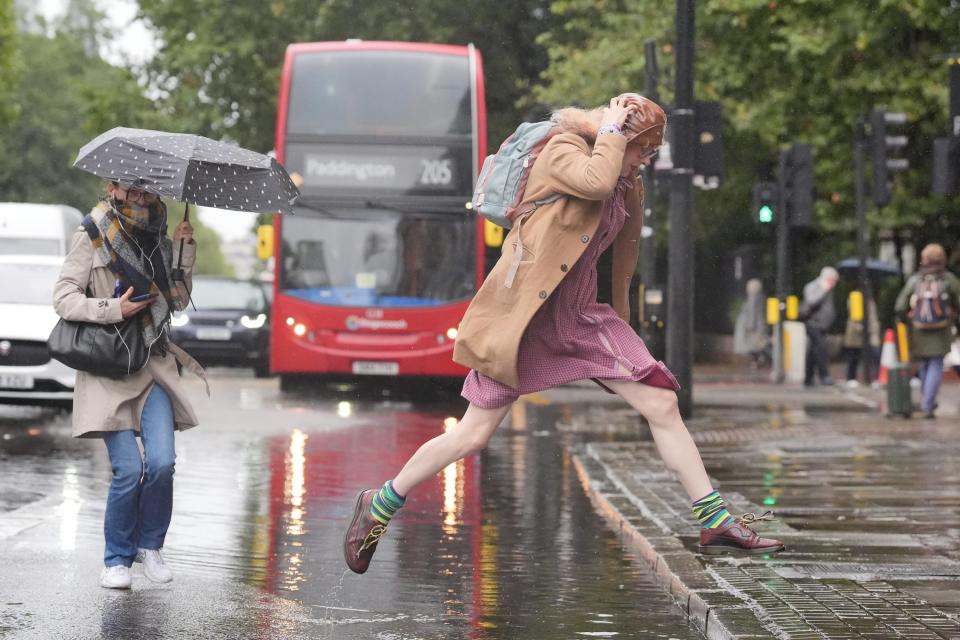
Londoners battle heavy rain
11:50 , Athena Stavrou


62 flood warnings and 117 flood alerts now in place, Environment Agency say
11:18 , Athena Stavrou
As of 11:15am, the Environment Agency had 62 flood warnings in place across England, meaning flooding is expected, and 117 flood alerts, meaning flooding is possible.
This is slightly less than the 121 flood alerts and 66 flood warnings seen earlier this morning.
We will continue to update the number of flood warnings throughout the day.
11:10 , Athena Stavrou
As areas of the country were battered by heavy rain on Thursday night, many commuters faced travel disruption on Friday morning.
Trains between Peterborough in the east Midlands and London King’s Cross were delayed because of flooding. The Marston Vale line in Bedfordshire, which operates services between Bedford and Bletchley, is suspended until Monday because of standing water on the track.
All lines were blocked between Bicester North and Banbury in Oxfordshire, with disruption expected until 3pm.
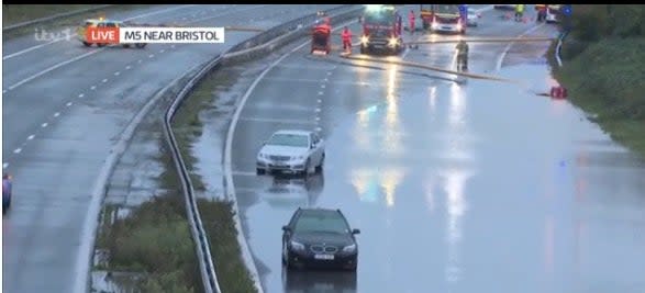
Meanwhile, National Highways said the M5 in Gloucestershire was closed northbound between junction 16 and junction 14 because of flooding. The motorway had reopened southbound between J14 and J15 but hour-long delays and up to four miles of congestion were still expected both ways.
The A421 in Bedfordshire was expected to remain closed in both directions on Friday between the A6 Bedford and M1 junction 13 near Marston Moretaine, as floodwater continued to be pumped clear from the junction.
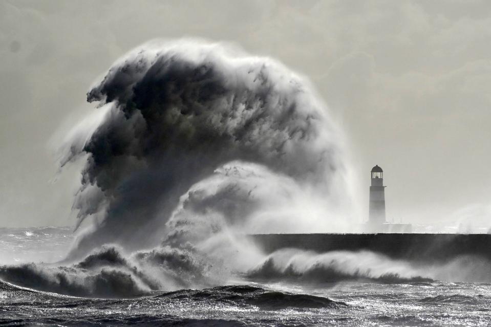
Waves crash against the lighthouse in Seaham Harbour, County Durham
10:30 , Athena Stavrou

Pictures from M5 as road remains closed amid flooding
10:03 , Athena Stavrou

Flood alerts and warnings in place
09:57 , Athena Stavrou
As of 9:30am, the Environment Agency had 66 flood warnings in place across England, meaning flooding is expected, and 122 flood alerts, meaning flooding is possible.
Following heavy overnight rain, roads and rail routes have been cut off on Friday leaving travellers facing severe delays.
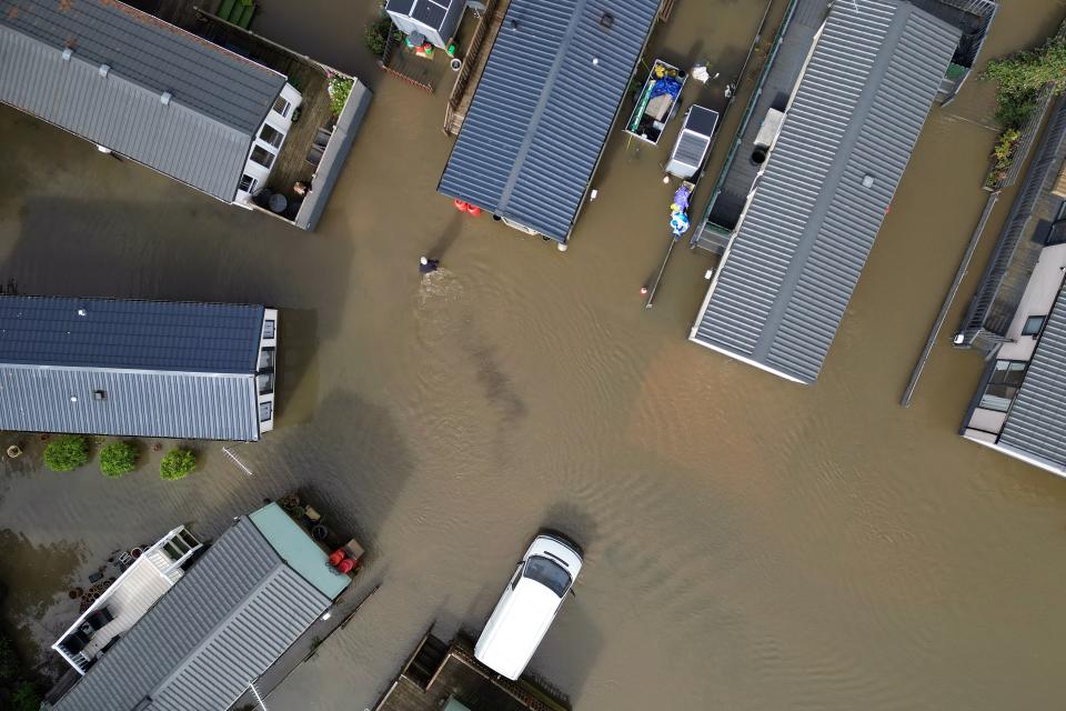
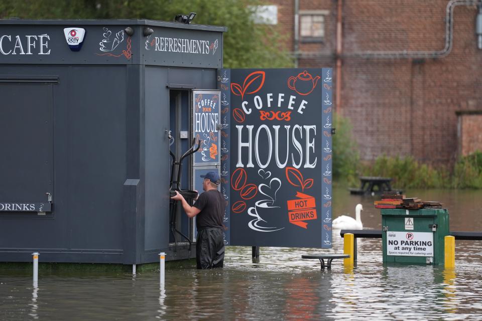
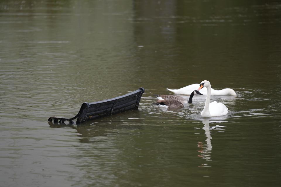
Images have also shown football pitches and car parks completely flooded as areas of the country, particularly the south and West Midlands .
Tewkesbury Borough Council, in Gloucestershire, has been handing out sandbags to people to help protect their homes against flooding. Parts of the country had more than the monthly average rainfall on Monday and there were further downpours on Wednesday.
About 385 properties were flooded in Hertfordshire, Bedfordshire, Northamptonshire, Kent and the home counties, according to the Environment Agency.
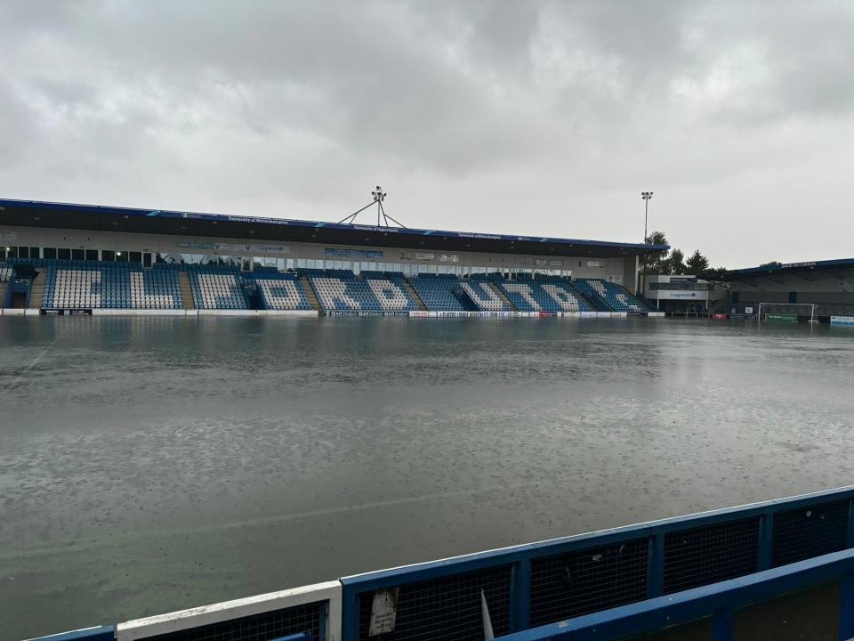
Football stadium pitch completely flooded
09:28 , Athena Stavrou
AFC Telford have shared shocking images of their waterlogged football pitch after the area was hit by heavy rainfall overnight,
Images shared to social media show the pitch completely covered in water as other pictures show the club’s changing rooms also flooding.
The team said large quantities of standing water and sludge were on its concourses and through its offices.
Tesco car park flooded after night of heavy rain
09:21 , Athena Stavrou
Shocking footage has shown a Tesco car park completely flooding following another night of heavy rainfall.
The store, believed to be on Marcham Road in Abingdon, Oxford, appears to still be open.
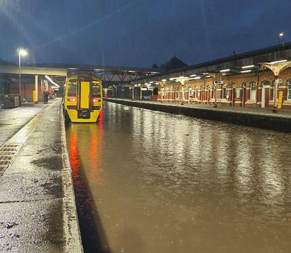
Train journeys affected as railways flood
09:06 , Athena Stavrou
Train passengers have been hit by travel delays as railways flood amid heavy rainfall.
Images from Wellington station in the West Midlands show train tracks filled with water as people across the midlands and south are hit by travel disruption.
Network Rail said journeys between Shrewsbury and Wolverhampton are affected as it is working to reduce water levels to ensure the line can open as soon as possible.
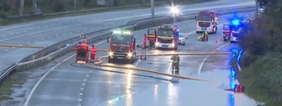
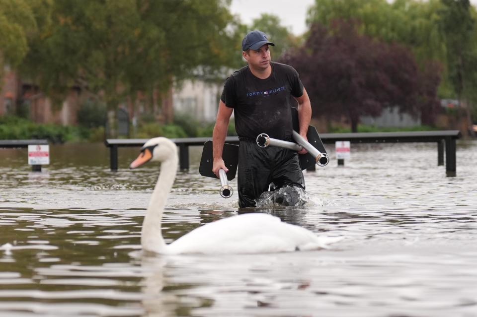
Motorists rescued from M5 amid flooding
08:29 , Athena Stavrou
Motorists had to be rescued from their cars on the M5 overnight as heavy rain and flooding left them stranded.
Parts of the route remain closed off this morning after Avon Fire and Rescue Service were called at around 1am to rescue three people stuck on the road.
National Highways says the M5 is closed northbound between J16 and J14 and the southbound carriageway is closed between J14 and J15 as emergency services work to clear the flooding.
It comes as heavy rain continues to fall on some parts of the country following a week of wet weather and flooding.
As of 6am, the Environment Agency had 63 flood warnings in place across England, meaning flooding is expected, and 121 flood alerts, meaning flooding is possible.
The weather warnings in place on Friday morning
06:00 , Alex Ross
As we approach 6am, here are the current weather warnings in place for the UK, issued by the Met Office.
The amber warning for rain is due to expire at 6am, but the yellow weather warning for the Midlands and the south of the country will end at 9am.
Meanwhile, the weather forcast for 7am shows a dry start to the day for many.

In pictures: Look back at the flooding caused by rain fall this week
04:22 , Alex Ross
Earlier this week, before Thursday night’s rain, many parts of the country were impacted by heavy rain.
In Northamptonshire, residents at the Billing Aquadrome Holiday Park had to be evacuated due to flooding on Tuesday night.
AFC Wimbledon in south London said its pitch suffered “significant damage” after the nearby River Wandle broke its banks.
Here’s some pictures looking back:


Swimming pool has to close due to heavy rain
02:22 , Alex Ross
In Bristol, a popular swimming pool has had to close after heavy rain earlier this week damaged its roof.
The Bristol South Swimming Pool had recently reopened after a refubishment, but following downpours earlier this week, and subsequent roof damage, the pool has had to close “with immediate effect”.
It’s not yet known when it will reopen.
Met Office report ‘unsettled’ Thursday
Friday 27 September 2024 00:22 , Barney Davis
Check your journeys before you travel – Network Rail
Friday 27 September 2024 00:10 , Alex Ross
Network Rail, which manages stations and railway lines across the country, has issued a warning to passengers who will be catching services in the morning.
Following the wet weather tonight in many areas of the country, the group warns rain can slow down journeys, causing disruptions for users.
Flooding reported in Chipping Campden, in Cotswolds
Thursday 26 September 2024 23:59 , Barney Davis
More than 50 flood warnings in place as UK deluged by rain and high winds
Thursday 26 September 2024 23:19 , Barney Davis
As of 11.20pm, the Environment Agency had 51 flood warnings in place across England, meaning flooding is expected, and 120 flood alerts, meaning flooding is possible.
Areas of Bedfordshire, Northamptonshire and Oxfordshire are listed as being the most vulnerable.
The Met Office said: “Slow moving showers and thunderstorms will develop through the afternoon, merging into a large band of heavy rain through the evening, before clearing slowly south overnight.
“Some places, especially across central and eastern parts of the warning area, are likely to receive 30-40mm in three hours or less, and perhaps 50-60mm or more in around six hours.
“This rain will fall onto already saturated ground and affect communities recovering from recent flooding. Travel disruption and further flooding is likely, with rivers continuing to rise after the rain clears.”
‘Anyone for waterpolo?’ Telford FC call for volunteers as stadium flooded
Thursday 26 September 2024 23:11 , Barney Davis
FLOOD:
This evening’s thunderstorm over Wellington has deluged the SEAH Stadium ⛈️👇🏻🌊
If you are available tomorrow (Friday) from 9 am onwards we’d welcome any help you could give to help us get things straightened up and dried out. pic.twitter.com/YxHm8WKr1n— AFC Telford United (@telfordutd) September 26, 2024
What the weather will be like at the weekend
Thursday 26 September 2024 22:22 , Alex Ross
Looking past the wet weather tonight and on Friday, the Met Office is forecasting a chilly Saturday before more wet weather on Sunday.
Met Office deputy chief neteorologist David Oliver said: “The rain will clear south during Friday allowing Arctic air to cross the country. This gives a much colder but quieter interlude in the south on Saturday, although a few showers will spread across northern areas.
“An area of low pressure then moves in from the southwest later in the weekend and crosses the UK during Sunday and Monday.
“Although there is still some uncertainty about the exact behaviour of this system and therefore where may see any impacts, it will bring the potential for some wet and windy weather late on Sunday and into the start of next week. Stay up to date with the latest forecast for your area.”
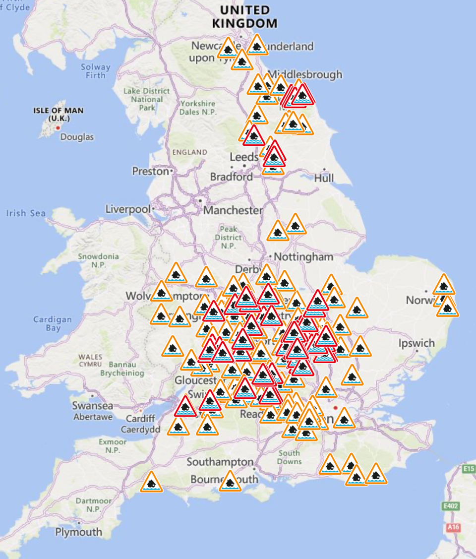
Mapped: 44 red and yellow flood alerts issued in England
Thursday 26 September 2024 22:18 , Barney Davis
Alternative means of travel
Thursday 26 September 2024 21:22 , Alex Ross
While the rain comes down in many areas of the country, we look back here at a picture taken today on the River Cam in Cambridge where passengers on a boat protect themselves from the downpours.
Cambridge is under an amber alert tonight, which means flooding is likely.

More flood warnings issued across England
Thursday 26 September 2024 20:48 , Barney Davis
As of 8.46pm, the Environment Agency had 40 flood warnings in place across England, meaning flooding is expected, and 114 flood alerts, meaning flooding is possible.
Areas of Bedfordshire, Northamptonshire and Oxfordshire are listed as being the most vulnerable.
The Tornado and Storm Research Organisation (Toro) is also forecasting that much of the South East could see lightning, winds up to 50mph and even “isolated brief tornadoes”.
Important people adjust their driving behaviour and take extra care – National Highways
Thursday 26 September 2024 20:30 , Alex Ross
With yellow and amber warnings for much of England warning of disruption on the roads, National Highways has urged caution from drivers.
National network manager Stephen Basterfield said: “With heavy rain expected to cause further flooding and disruption today and overnight its important people adjust their driving behaviour and take extra care.
“Road users should plan their journey and check the latest updates on diversion routes before they travel as these could be impacted with more rainfall.
“We have a section of our website dedicated to travelling when it is raining, as part of our guide to travelling in severe weather.”
Plenty of rain tonight
Thursday 26 September 2024 19:22 , Alex Ross
As the Met Office forecasts, and this graphic shows, heavy rain will fall over much of the UK tonight.
A wet evening with heavy spells of rain, possibly thundery, affecting parts of England and Wales ⚠️
Turning chilly in Scotland with a few showers 📉 pic.twitter.com/3gc8HOdhAg
— Met Office (@metoffice) September 26, 2024
Tewkesbury Borough Council handing out sandbags
Thursday 26 September 2024 19:17 , Barney Davis
A council in Gloucestershire is handing out sandbags to residents to help protect their homes against flooding.
Tewkesbury Borough Council posted on social media: “During extreme weather events, we provide sandbags for residents to protect their homes from flooding.
“Please be considerate to others who may need to protect their homes. Emergency sandbags are available to protect habitable areas of your home, rather than gardens or garages.
“Four sandbags are sufficient for most doorways, and during emergencies, officers will provision appropriately to ensure as many homes are protected as possible.”

Amber warning now in place across Midlands
Thursday 26 September 2024 18:48 , Barney Davis
Heavy rain is likely to cause flooding and transport disruption this evening until 6am.
The Met Office said: “Some places, especially across central and eastern parts of the warning area, are likely to receive 30-40mm in three hours or less, and perhaps 50-60mm or more in around six hours.
“This rain will fall onto already saturated ground and affect communities recovering from recent flooding. Travel disruption and further flooding is likely, with rivers continuing to rise after the rain clears.”
Flash flooding strikes UK with nearly 40 warnings in place
Thursday 26 September 2024 18:37 , Barney Davis
Parts of Britain have been struck by more flash floods as the Met Office warns of more heavy rain.
The forecaster has issued an amber warning for areas of the Midlands and south of the country, which came into force at 6pm on Thursday and will last for 12 hours.
Yellow rain warnings had already been in place for large parts of England and Wales and western parts of Northern Ireland.
As of 6.17pm, the Environment Agency had 38 flood warnings in place across England, meaning flooding is expected, and 105 flood alerts, meaning flooding is possible.
Warning to road users
Thursday 26 September 2024 18:20 , Alex Ross
As roads look likely to be impacted by heavy rain tonight, the Environment Agency is reminding peopel to take care when driving through flood water.
Kate Marks, flood duty manager, said “We urge people to plan their journeys carefully, follow the advice of local emergency services on the roads and not to drive through flood water – it is often deeper than it looks and just 30cm of flowing water is enough to float your car.”
Pictures: People stranded in floods and heavy rain
Thursday 26 September 2024 18:02 , Barney Davis


Met Office map shows storms circling Midlands
Thursday 26 September 2024 17:38 , Barney Davis
A wet evening with heavy spells of rain, possibly thundery, affecting parts of England and Wales ⚠️
Turning chilly in Scotland with a few showers 📉 pic.twitter.com/3gc8HOdhAg
— Met Office (@metoffice) September 26, 2024
Environment Agency teams ‘on the ground’
Thursday 26 September 2024 17:16 , Alex Ross
With heavy rainfall forecast across many areas of the UK, including some areas already under water, the Environment Agency (EA) has been busy working with impacted communities.
As of 4pm, there were 30 flood warnings in place, where flooding is likely, plus 84 flood alerts, where flooding could happen.
Kate Marks, flood duty manager at the EA, said: “Heavy rainfall across the country means that significant river and surface water flooding impacts are possible in parts of central England today and into Friday. Minor river flooding impacts are also possible in parts of north-east England today and Friday.
“Environment Agency teams continue to be out on the ground, supporting local authorities in responding to surface water flooding.
“People should check their flood risk, sign up for free flood warnings and keep up to date with the latest situation as well as following @EnvAgency on X for the latest flood updates.”
Weather warnings mapped
Thursday 26 September 2024 16:20 , Alex Ross
Here’s a graphic showing the weather warnings in place and the amount of rain expected in each region
Some early footage of the wind and rain in London tonight
Thursday 26 September 2024 16:06 , Alex Ross
Thursday 26 September 2024 15:56 , Alex Ross
The amber warning is in place for many areas of the country badly impacted by rain earlier this week.
This includes St Ives in Cambridgeshire, where areas are still under water.
Met Office chief meteorologist, Neil Armstrong, said: “he rain will fall onto already saturated ground, potentially affecting communities still recovering from recent flooding.”

What to expect in areas facing yellow and amber warning
Thursday 26 September 2024 15:39 , Alex Ross
As many parts of the country face a blustery and wet night with the chance of disruptions, the Met Office has issued a list of what people should expect under each of the warnings.
For a yellow weather warning:
-
There is a slight chance of power cuts and loss of other services to some homes and businesses
-
There is a small chance that homes and businesses could be flooded, causing damage to some buildings
-
Where flooding occurs, there is a slight chance of delays or cancellations to train and bus services
-
Spray and flooding could lead to difficult driving conditions and some road closures
-
There is a small chance that some communities will become cut off by flooded roads
-
There is a small chance of fast flowing or deep floodwater causing danger to life
For a amber weather warning:
-
Spray and flooding probably leading to difficult driving conditions and some road closures
-
Homes and businesses are likely to be flooded, causing damage to some buildings
-
A good chance some communities will be cut off by flooded roads
-
Delays and some cancellations to train and bus services are likely
-
Power cuts and loss of other services to some homes and businesses likely
Weather warnings across UK
Thursday 26 September 2024 15:36 , Alex Ross
Here’s the latest map showing the weather warnings in place for rain tonight.
A yellow weather warning for eastern Northern Ireland will end at 6pm, for the north-east at midnight and for the Midlands and the south at 9am.
A more severe amber alert is in place for a central region, and is expected to end at 6pm. The warning states: “Heavy rain is likely to cause flooding and transport disruption this evening and overnight.”
Tornado alert issued
Thursday 26 September 2024 15:24 , Alex Ross
The Tornado and Storm Research Organisation (Toro) is forecasting much of the south-east to see lightning, winds up to 50mph and even “isolated brief tornadoes”.
This includes much of East Anglia, the south-east Midlands and central southern England.
It comes after the Met Office issued an amber warning earlier on Thursday for areas of the Midlands and south of the country, set to come into force at 6pm on Thursday and last for 12 hours.

Looking further ahead
Thursday 26 September 2024 14:43 , Alex Ross
Following Friday, the Met Office says the rain will clear and the country will experience colder conditions.
Met Office deputy chief meteorologist David Oliver said: “The rain will clear south during Friday allowing Arctic air to cross the country.
“This gives a much colder but quieter interlude in the south on Saturday, although a few showers will spread across northern areas. An area of low pressure then moves in from the southwest later in the weekend and crosses the UK during Sunday and Monday.”
Measures of rainfall over next 24 hours
Thursday 26 September 2024 14:08 , Alex Ross
The Met Office has produced a tidy visualisation that shows the amount of rainfall predicted over the next 24 hours.
The north east and central England, where there is an amber alert for rain, face the highest levels.
Rainfall totals will be building through today and overnight 🌧️
Here are the latest 24 hours rainfall totals until Friday morning, with northeast England and parts of central England seeing the greatest amounts 👇 pic.twitter.com/lf03Yct3dx
— Met Office (@metoffice) September 26, 2024
Amber warning in place until 9am on Friday
Thursday 26 September 2024 13:40 , Alex Ross
Areas affected by the amber warning, including Milton Keynes, Oxfordshire, Cambridgeshire, Leicestershire and the West Midlands, could see 30-40mm of rainfall within three hours, according to the Met Office.
According to the warning, the weather could lead to difficult driving conditions and road closures, homes and businesses are likely to be flooded and there is a “good chance” some communities will be cut off due to floods.
Delays and cancellations to train and bus services and power cuts are also likely.
How much rain are we expecting?
Thursday 26 September 2024 13:00 , Alex Ross
The Met Office says some places, especially across the central and eastern parts of the amber warning area, will see 30 to 40 mm of rainfall in up to three hours.
This could increase to 50 to 60 mm overnight in some areas.
A 3 way split in the weather this afternoon 👇
Heavy outbreaks of rain and strong gusty winds across northern England and Northern Ireland ⚠️
Heavy, thundery downpours developing in the south 🌩️
Drier and brighter for Scotland 🌤️ pic.twitter.com/ETXt6JRS5q
— Met Office (@metoffice) September 26, 2024
‘Increased risk of impacts’
Thursday 26 September 2024 12:38 , Alex Ross
The Met Office has now provided some commentary on the recently issued amber warning, explaing what many parts of the UK should face this afternoon and evening.
As we’ve already said, many parts of the UK are covered by a yellow warning for rain, although a central region of England has seen its alert heightened to amber this morning.
Met Office Chief Meteorologist, Neil Armstrong, said: “We are expecting an area of slow-moving showers and thunderstorms to develop this afternoon and evening across parts of the Midlands.
“The rain will fall onto already saturated ground, potentially affecting communities still recovering from recent flooding. An amber warning as been issued covering the areas of increased risk of impacts.
Flood warnings in place
Thursday 26 September 2024 12:00 , Alex Ross
Over the past 24 hours, 19 flood warnings have been removed by the Environment Agency, but there are still 27 in place, where flooding is expected.
The flood warnings, most of which are in Bedfordshire and Northamptonshire, are in place due to further rain expected on Thursday and Friday.
There are also 65 flood alerts in place, where flooding is possible.
Visualisation shows why amber warning is in place
Thursday 26 September 2024 11:45 , Alex Ross
The Met Office has issued a graphic showing how the band of rain will impact central England from tonight into Friday morning:
What should people expect in am amber warning?
Thursday 26 September 2024 11:30 , Alex Ross
The Met Office has issued an amber warning for rain for a central region of England. Here is what the agency says people should expect:
-
Spray and flooding probably leading to difficult driving conditions and some road closures
-
Homes and businesses are likely to be flooded, causing damage to some buildings
-
A good chance some communities will be cut off by flooded roads
-
Delays and some cancellations to train and bus services are likely
-
Power cuts and loss of other services to some homes and businesses likely
In pictures: Areas still flooded from rain earlier this week
Thursday 26 September 2024 11:20 , Alex Ross
In Northamptonshire, some low lying areas were badly impacted by the rain earlier this week.
At the Billing Aquadrome leisure park, residents had to be evacuated from their homes, while several main roads were also shut due to flooding.
Pictures today show how some areas are still impacted.
Amber weather warning issued by Met Office
Thursday 26 September 2024 11:13 , Alex Ross
The Met Office has just raised its warning for heavy rain for a central part of England from a yellow alert to amber.
This means that heavy rain is likely to cause flooding and transport disruption this evening and overnight.
The region has already suffered flooding following downpours earlier in the week, in particular, in low lying areas in Northamptonshire and Bedfordshire.
The south of England and Wales will be the worst affected areas today
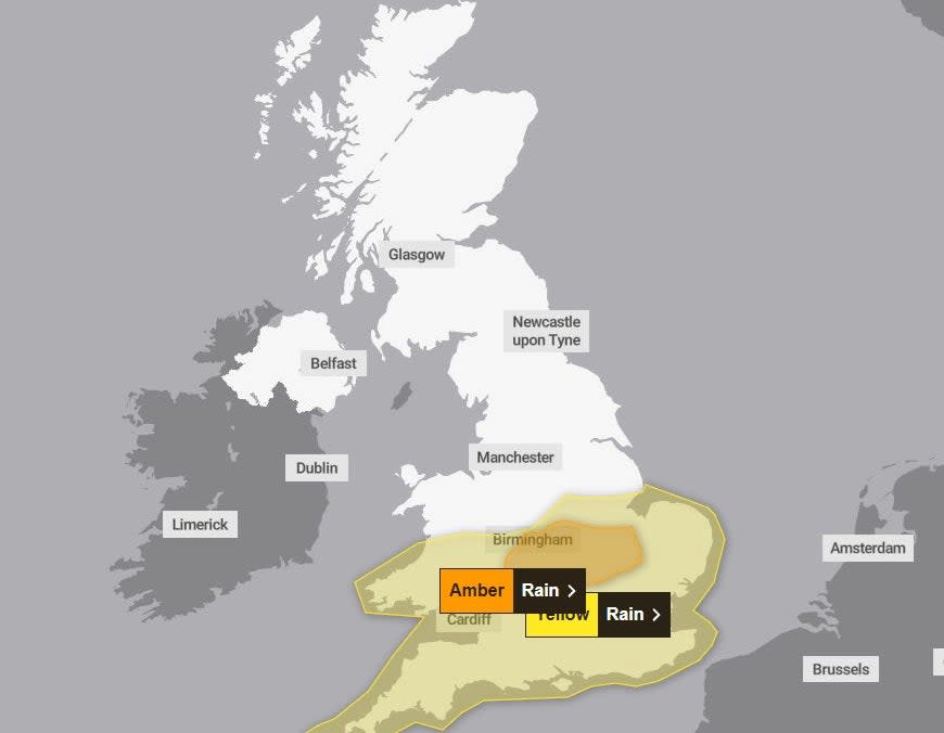
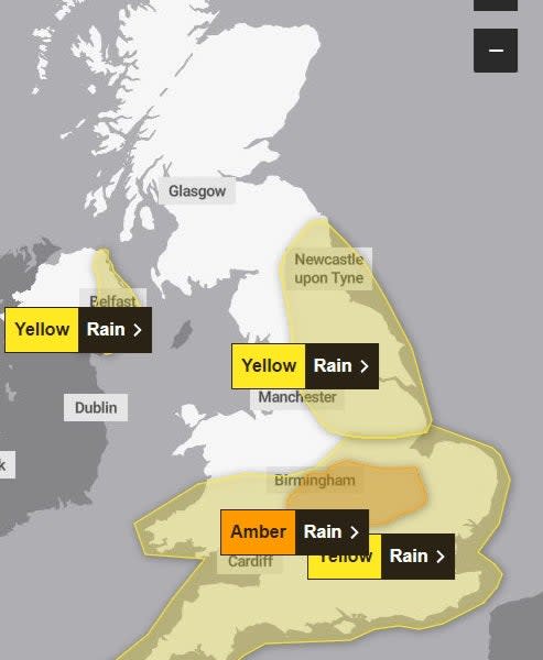
Thursday 26 September 2024 10:20 , Alex Ross
With rain forecast across many regions of the UK today, a yellow weather warning is in place for the south of England and Wales, and will remain in place until Friday morning at 9am.
The Met Office says people in areas such as Birmingham, London, Bristol and Cardiff should expect heavy rain with the potential for flooding and disruption to transport.
There’s also a chance of thunderstorms.
The Met Office says: “Whilst some areas will miss the worst, heavy showers and some thunderstorms will occur during today, potentially becoming more organised across a swathe of Wales and into central and eastern England during Thursday evening and on into early Friday morning.”
Movement of bands of rain across the UK
Thursday 26 September 2024 09:53 , Alex Ross
As this graphic from the Met Office shows, the day begins with heavy showers in the north east before later in the day, from around 11am, bands of rain drift up through the south of the country where there is a yellow weather warning in place.
The Latest News
-
September 27, 2024Britain’s business regulatory agency signs off on Amazon investment in Anthropic AI – UPI.com
-
September 27, 2024England and Great Britain men’s head coach Revington departs
-
September 27, 2024Naomi Campbell banned from running Fashion for Relief charity as U.K. regulator cites
-
September 27, 2024Flight disruption warning for British Airways passengers
-
September 27, 2024Innovate Change presents best online casino real money with high RTP games in New Zealand


